National Parks in Cape Breton Island

Cape Breton Highlands National Park is one of the two crown-jewel national parks in Atlantic Canada (Gros Morne in Newfoundland is the other). Covering nearly 1,000 sq. km (370 sq. miles) and stretching across a rugged peninsula from the Atlantic to the Gulf of St. Lawrence, this park is famous for its starkly beautiful terrain. It also features one of the most dramatic coastal drives in North America: think Big Sur, but greener. One of the great pleasures of this park is that it holds something for everyone, from tourists who prefer to sightsee from the comfort of their cars to those who prefer backcountry hiking in the company of bear and moose.
The mountains of Cape Breton are probably unlike those you're familiar with elsewhere. The heart of the park is fundamentally a huge plateau; in the vast interior, you'll find a flat, melancholy landscape of wind-stunted evergreens, bogs, and barrens. This is called the "taiga," a name that refers to the zone between tundra and the northernmost forest. In this largely untracked area (Nova Scotia's largest remaining wilderness), you might find 150-year-old trees that are still only knee-high.
It's the park's edges that really capture your attention, though. On the western side of the peninsula, the tableland has eroded right into the sea, creating a dramatic landscape of ravines and ragged, rust-colored cliffs pounded by the ocean. The Cabot Trail, a paved road built in 1939, winds dramatically along the flanks of these mountains, offering extraordinary vistas and camera shots at every turn. On the park's eastern flank -- the Atlantic side -- the terrain's a bit less spectacular, but those lush green hills still offer a backdrop that's exceptionally beautiful.
Note that this section of the book focuses only on the park proper, which offers no lodging or services other than campgrounds. You can find limited lodging and restaurants in the handful of villages that ring the park, however.
Getting to Cape Breton National Park
Access to the park is via the Cabot Trail, which is very well marked by provincial signage. The entire loop is about 305km (190 miles), though the section that passes through the national park -- from the entrance at Chéticamp to the one at Ingonish -- is only about 105km (65 miles). You'll drive slowly to take in the vistas. Although the loop can be done in either direction, I would encourage you to drive it in a clockwise direction; the visitor center in Chéticamp offers a far more detailed introduction to the park.
Visitor Information at Cape Breton National Park
Two visitor information centers are located at either end of the park, in Chéticamp and Ingonish. Both are open daily from mid-May through mid-October, 8am to 7pm in summer (July–Aug) and 9am to 5pm during the shoulder seasons. The Chéticamp center has much more extensive information about the park, including a slide presentation, natural history exhibits, a cool large-scale relief map, and a very good bookstore. The park’s main phone number is tel. 902/224-2306 and the website is pc.gc.ca/en/pn-np/ns/cbreton.
Fees for Cape Breton National Park
A park pass is required for use of all services and facilities including campgrounds and trails while the park is open and can be purchased either at information centers or at tollhouses at the two main park entrances. Daily fees are C$9 adults, C$7.75 seniors, free for children under 17, C$17.50 family. Seasonal passes are available and also cover some historic sites; they cost C$75.25 for adults, C$64.50 for seniors and C$151.25 for families.
Scenic Drives in Cape Breton National Park
Cape Breton Highlands National Park basically only offers one drive, but it's a doozy: With few exceptions, it's jaw-droppingly scenic along nearly the entire route. The most breathtaking stretch is probably the 40km (25-mile) section from Chéticamp to Pleasant Bay ★★★ along the island's northwestern coast. Budget lots of extra time for driving this part, because you'll want to spend plenty of time at the pullouts gawking at the views, reading signs, and snapping digital photos. Other drivers will poke along, too. If you have time, there's even a nice little detour at the northern apex of the loop to Meat Cove.
If it's a foggy day, though, save yourself the entrance fee and time. Without the views, there's little reason to drive the loop and you'd be smart to wait for a day when the fog has lifted. Explore villages near your hotel in the atmospheric mist instead.
Check Your Brakes -- You need to be very confident about your car's brakes before setting out on the Cabot Trail. That's because the road rises and falls steeply, with considerable drama; cresting some ridges, you might even feel a mild sense of vertigo. Especially stressful on the brakes (when traveling the Trail clockwise) are the descents to Pleasant Bay, into the Aspy Valley, and off Cape Smokey. Test your brakes and check your tires long before you get close to the park -- don't wait until you're flying down a scenic hill, eyes off the road, and a big RV suddenly backs out into your path.
Hiking in Cape Breton National Park
The park offers no fewer than 25 distinct hiking tracks departing from the Cabot Trail. Many excursions are quite short and have the feel of a casual stroll rather than a vigorous tramp, but those determined to get a workout will find suitable trails, too. All the trails are listed, with brief descriptions, on the reverse side of the map you get when you pay your park entry fee at the gates.
One of the most rewarding short hikes is straight across the road from the information center in Ingonish. Freshwater Lake Lookoff is only .3km (.2-mile) return, but it’s as steep as it is short, climbing the side of a hill to a small clearing atop a rocky cliff where there’s a bench to sit and take in the picturesque view of Ingonish Beach with a large pond in the foreground and Cape Smokey in the background.
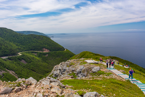
The Skyline Trail (see below) is perhaps the park’s finest; it offers oodles of altitude and views, without the climbing. You ascend a tableland from Chéticamp by car, then follow a 9km (6-mile) loop out along dramatic bluffs and through wind-stunted spruces and firs where moose might be browsing. A spur trail descends to a high, exposed point overlooking the surf and another slope across the Cabot Trial; it’s capped by blueberry bushes.
Farther along the Cabot Trail, Lone Shieling is an easy 800m (1/2-mile) loop through lush hardwood forest in a valley that's home to 350-year-old sugar maples. The re-created hut of a Scottish crofter (shepherd) is another cool feature of this trail.
If you're looking to leave the crowds behind, the Glasgow Lakes Lookoff is a relatively gentle 9km (6-mile) round-trip hike that takes you through barrens and scrubby forest to a rocky bald overlook with distant views of the ocean and some highland lakes. This trail is alternately swampy and rocky, so wear rugged footwear.
On the eastern shore, try the 4km (2 1/2-mile) hike to Middle Head, which starts beyond the Keltic Lodge resort. This dramatic, rocky peninsula thrusts well out into the Atlantic. The trail is wide and relatively flat, and you'll cross open meadows with wonderful views both to the north and south. The tip of the peninsula is grassy and open, a good spot from which to watch for passing whales -- or see waves crashing in after a storm. Allow about 2 hours for a relaxed walk out to the point and back.
Biking in Cape Breton National Park
The full 290km (180-mile) Cabot Trail loop is the ironman tour for bike trekkers, both arduous and rewarding. The route twists up ravines and plummets back down toward the coast. One breathtaking vista after another unfolds, and the plunging, brake-smoking descent from Mt. MacKenzie to Pleasant Bay is one serious cyclists aren't likely to forget in a lifetime. Campgrounds and motels are well spaced out here, too, making a 3- or 4-day excursion easy. Disadvantages? The road is almost uniformly narrow and free of shoulders, so you'll be battling constantly with errant motor-home drivers for the side of the road. That can be a bit harrowing.
If you're not inclined to pedal the entire loop, pick and choose. Especially scenic stretches for bikers in good shape include the sections from Chéticamp to Pleasant Bay and back and the climb and descent from Lone Shieling eastward to the Aspy Valley.
Note that mountain bikes are allowed on just a few trails within the park -- check with the visitor center when you arrive for details about any new restrictions. The longest backcountry trail is the 12.2km (7.6-mile) route called Salmon Pools, a level trail that follows the bottom of the Chéticamp River canyon with towering cliffs. Bikes are permitted on part of this trail.
Camping in Cape Breton National Park
The park has five drive-in campgrounds. The largest are at Chéticamp (on the west side) and Broad Cove (on the east), both of which have the commendable policy of never turning a camper away; even if all regular sites are full, they'll still find a place for you to pitch a tent or park your RV. All these campgrounds are well run and well maintained, though Chéticamp and Broad Cove have the most facilities, including three-way hookups for RVs.