
Biking
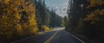
An easy and scenic route for a bike tour follows winding Sunday River Road several miles into the foothills of the Mahoosuc mountain range. Start near the Sunday River ski resort, heading west along the river past a tranquil scene with a covered bridge. Eventually, you head into forested hills (the road turns to dirt). This dead-end road is lightly traveled, and views from the valley are rewarding. Ask locally, or consult a local cyclists' hangout (such the two listed just below) for a map.
Serious mountain bikers should head for the Sunday River Mountain Bike Park (tel. 207/824-3000) at the ski area, open Friday to Sunday during summer. Fifteen mountain-bike trails of every caliber are open to bikers, totaling 20 miles. Experienced riders will enjoy taking their bikes by chairlift to the summit, then careening back down on service roads and ski trails. Visit the South Ridge Lodge first for your rental, then hit the slopes.
Bethel Outdoor Adventure, 121 Mayville Rd., Bethel (tel. 800/533-3607 or 207/824-4224; www.betheloutdooradventure.com), rents off-road bikes for $25 per day. The center is located right where U.S. Route 2 crosses the Androscoggin River, on the way from Bethel to Sunday River.
Boating
Canoe rentals and shuttles for exploring the Androscoggin River can be arranged by Bethel Outdoor Adventure . You can also hire a guide here to take you out by canoe or kayak, or sign up for a 2-hour lesson to brush up on skills before heading out on your own.
Golf
The Bethel Inn's Country Club (tel. 207/824-6276) is an unusually scenic 18-hole golf course right next to the inn. Greens fees for 18 holes cost $30 to $50 per person. Clubs and golf carts can be rented, and the club also has a driving range; tee times are not mandatory, but they're strongly recommended in high season.
Hiking
The Appalachian Trail crosses the Mahoosuc Range northwest of Bethel. Many who have hiked the entire 2,000-mile trail say this stretch is the most demanding on knees and psyches, but also one of the mostly weirdly beautiful. The trail doesn't forgive; it foregoes switchbacks in favor of sheer rocky ascents and descents. It's also hard to find water along the trail here during dry weather. Still, it's worth the effort for the views and unrivaled sense of remoteness.
One stretch of the trail crosses Old Speck Mountain, which at 4,170 feet is (surprisingly) Maine's third-highest peak. Views from the wooded summit are nonexistent since an old fire tower closed, but an easy-to-moderate spur trail on the lower end of the trail ascends an 800-foot cliff called "The Eyebrow" (not for those afraid of heights) with a good vantage point on the rugged terrain of the Notch. Or you can continue past the summit down into a bowl containing Old Speck Lake and a primitive campsite. Look for the well-signed parking lot where Route 26 intersects the trail to the state park; park, pay, strap on boots (spots are muddy), and head south on the A.T. to climb Old Speck; in one-tenth of a mile, you'll intersect the Eyebrow Trail, which you can follow to the overlook. Continuing upward, you'll encounter mild cascades and increasing views of the valley foliage.
Across Route 26, the A.T. runs east and up Baldpate Mountain (the face and top have patches of open ledge) on its meandering way toward the trail's finish line at Mount Katahdin. Baldpate is higher than you might think: Its summit is only about 400 feet lower than the rival it directly faces.
The Appalachian Mountain Club's Maine Mountain Guide contains detailed information about these and other area hikes; pick up a copy if you're a serious walker.
Note: This information was accurate when it was published, but can change without notice. Please be sure to confirm all rates and details directly with the companies in question before planning your trip.