
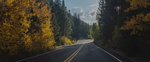


Gila National Forest, which offers some of the most spectacular mountain scenery in the Southwest, comprises 3.3 million acres in four counties. Nearly one-fourth of that acreage (790,000 acres) comprises the Gila, Aldo Leopold, and Blue Range wildernesses. Its highest peak is Whitewater Baldy, at 10,892 feet. Within the forest, six out of seven life zones can be found, so the range of plant and wildlife is broad. You may see mule deer, elk, antelope, black bear, mountain lion, and bighorn sheep. Nearly 400 miles of streams and a few small lakes sustain healthy populations of trout as well as bass, bluegill, and catfish. Anglers can head to Lake Roberts, Snow Lake, and Quemado Lake.
Just the Facts -- For more information on the national forest, contact the U.S. Forest Service, Forest Supervisor's Office, 3005 E. Camino del Bosque, Silver City, NM 88061 (tel. 575/388-8201; www.fs.fed.us).
The national forest has 29 campgrounds, all with toilets and six with drinking water. Car and backpack camping are also permitted throughout the forest.
Hiking & Other Activities
Within the forest are 1,490 miles of trails for hiking and horseback riding, and in winter, cross-country skiing. Outside the wilderness areas, trail bikes and off-road vehicles are also permitted. Hiking trails in the Gila Wilderness, especially the 41-mile Middle Fork Trail, with its east end near Gila Cliff Dwellings, are among the most popular in the state and can sometimes be crowded. If you are more interested in communing with nature than with fellow hikers, however, you will find plenty of trails to suit you, both in and out of the officially designated wilderness areas.
Most of the trails are maintained and easy to follow. Trails along river bottoms, however, have many stream crossings (so be prepared for hiking with wet feet) and may be washed out by summer flash floods. It's best to inquire about trail conditions before you set out. More than 50 trail heads provide roadside parking.
Some of the best hikes in the area are the Frisco Box, Pueblo Creek, Whitewater Baldy, the Catwalk and Beyond, the Middle Fork/Little Bear Loop, and the Black Range Crest Trail. The Gila National Forest contains several wilderness areas that are off-limits to mountain bikes, including the Gila, Aldo Leopold, and the Blue Range Primitive Area. However, cyclists can access quite a few trails. Some to look for are the Cleveland Mine trail, Silver City Loop, Continental Divide, Signal Peak, Pinos Altos Loop, Fort Bayard Historical Trails, and Forest Trail 100.
The Catwalk National Recreation Trail (tel. 575/539-2481), 68 miles north of Silver City on US 180, then 5 miles east of Glenwood via NM 174, is a great break after a long drive. Kids are especially thrilled with this hike. It follows the route of a pipeline built in 1897 to carry water to the now-defunct town of Graham and its electric generator. About a quarter mile above the parking area is the beginning of a striking 250-foot metal causeway clinging to the sides of the boulder-choked Whitewater Canyon, which in spots is 20 feet wide and 250 feet deep. Along the way, you'll find water pouring through caves and waterfalls spitting off the cliff side. Farther up the canyon, a suspension bridge spans the chasm. Picnic facilities are near the parking area. There's a $3 fee per car.
Note: This information was accurate when it was published, but can change without notice. Please be sure to confirm all rates and details directly with the companies in question before planning your trip.