
Flaming Gorge National Recreation Area
24 miles W of Rock Springs
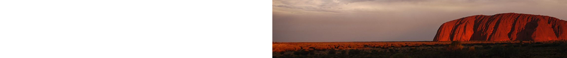
By May 1869, the Union Pacific had laid its tracks across Wyoming and pinned them to the eastbound rails with a golden spike. The town of Green River, 15 miles west of Rock Springs, was only a year old. And that May, 10 frontiersmen and ex-soldiers climbed off the train, led by a veteran who'd lost his arm in the Civil War. They jumped into stout wooden boats and set off down the Green River. As they slid through red canyons with the cliffs peaking high above, almost singed yellow along the rims, they named the place Flaming Gorge.
The expedition continued down the Green, which merged into the Colorado River, and then continued on into the Grand Canyon, weaving through boulders, portaging sandbars, and being sucked through rapids. Three men decided to hike out rather than risk the rapids. They were later found bristling with arrows. The remaining seven survived. The leader went on to map and record the "Great American Desert" and later helped organize and direct the U.S. Geological Survey. The one-armed Civil War veteran, a famous river runner, was of course John Wesley Powell.
Today a 455-foot dam, 15 miles into Utah, backs the river onto itself for 91 miles, nearly to the town of Green River. Each summer, jet-boaters, water-skiers, and anglers skim the surface of the reservoir, while paddlers drop in below the dam for scenic and adventurous floats in the wake of Powell's boats.
Getting There -- Take I-80 west from Rock Springs for 15 miles to the town of Green River at the junction of Wyo. 530.
Visitor Information -- For information before you arrive, contact the District Ranger (tel. 435/784-3445; www.fs.fed.us/r4/ashley). Once you're in the area, stop at the U.S. Forest Service's visitor center in Green River at 1450 Uinta Dr. (tel. 307/875-2871) to pick up maps and brochures.
Admission & Regulations -- If you're boating, admission to the 190,000-acre Flaming Gorge National Recreation Area is $5 per vehicle per day or $15 for a 7-day pass. The Forest Service's regulations here are mostly common sense, aimed at preserving water quality and protecting the forest and historic sites. In addition, Wyoming and Utah fishing and boating regulations apply in those states' sections of the recreation area. Leashed dogs are permitted on trails.
A Driving Tour
As you drive south from Green River on Wyo. 530, the cactus and sagebrush-filled Devils Playground badlands and the rock formations of Haystack Buttes will be to your right. Wyo. 530 runs the length of the recreation area's west side and provides access to the Flaming Gorge Reservoir at the Buckboard Crossing Area, 20 miles south, where a full-service marina operates during the summer.
From Wyo. 530, pick up Utah 44 just across the state line in Manila, Utah. Utah 44 runs south then east for 27 miles to pick up U.S. 191. Along this route you'll catch glimpses of Utah's Uinta Mountains to the west and may see bighorn sheep in nearby Sheep Creek Canyon, which has been designated a special geological area by the Forest Service because of its dramatically twisted and upturned rocks. A mostly paved 11-mile loop road cuts off from Utah 44, offering a half-hour tour of this beautiful, narrow canyon, with its lavish display of rocks that have eroded into intricate patterns, a process that began with the uplifting of the Uinta Mountains millions of years ago. This loop may be closed in winter.
Eventually, you'll come to the Red Canyon Overlook on the southern edge of the gorge, where a rainbow of colors adorns 1,000-foot-tall cliffs. The Red Canyon Visitor Center (open daily 8am-6pm in summer) is nearby, as is Flaming Gorge Dam.
To head back to Wyoming, take U.S. 191 away from the eastern edge of the gorge. From the junction of Utah 44 and U.S. 191, it's 16 miles to the border. Once you're at the state line, it's 30 miles to the turnoff for Firehole Canyon, an access to the gorge that offers views of the magnificent spires known as Chimney Rocks. Keep going north on U.S. 191 and you'll hit I-80 again.
Getting Outside
For more information about the Utah portion of Flaming Gorge National Recreation Area, including additional outdoor recreational activities and outfitters, lodging options, and other nearby sites of interest, see Frommer's Utah.
Boating -- Three marinas on Lake Flaming Gorge provide boat rentals, fuel, launching ramps, and boating and fishing supplies. Cedar Springs Marina (tel. 435/889-3795; www.cedarspringsmarina.com) is 2 miles west of Flaming Gorge Dam; Lucerne Valley Marina (tel. 435/784-3483; www.flaminggorge.com) is on the west side of the lake, 7 miles east of Manila; and Buckboard Marina (tel. 307/875-6927) is also on the west side of the lake, off Wyo. 530, 22 miles north of Manila.
Camping -- The U.S. Forest Service maintains about 20 RV and tent campgrounds in the area (about $10-$30 a night), and there are also many primitive riverside sites. Contact the Forest Service visitor center in Green River (tel. 307/875-2871) for more information.
Fishing -- You might want to bring along a muscular friend if you plan to fish Lake Flaming Gorge, which is famous as the place to catch record-breaking trout, such as the 51-pound, 8-ounce lake (Mackinaw) trout caught in 1988; the 26-pound, 2-ounce rainbow caught in 1979; or the 33-pound, 10-ounce brown caught in 1977. You'll also see other cold-water species such as smallmouth bass and kokanee salmon. Fishing is popular year-round, although ice-fishermen are warned to make sure the ice is strong enough to hold them. For fishing information and excursions, call Conquest Expeditions (tel. 435/784-3370 or 801/244-9948; www.conquestexpeditions.com).
Killpecker Sand Dunes
Killpecker Sand Dunes: 40 miles N of Rock Springs; 140 miles SE of Jackson
North of Rock Springs and east of Eden (I'm not kidding…it's a small town) swell the Killpecker Sand Dunes -- the largest active dunes in North America. Here hikers can scale and descend the heaving hills of white sand, where the noon heat shimmers and the midnight cold cuts. Rock climbers trek to Boar's Tusk, a standing volcanic plug, ethnography buffs seek the White Mountain Petroglyphs, and photographers with high-powered telephoto lenses should be on the lookout for wild horses.
Bird-watchers will especially enjoy the Seedskadee Wildlife Refuge, where they may see geese, sandhill cranes, and great blue herons along the miles of marshes along the Green River.
Getting There -- To get to the dunes, drive Wyo. 191 north from Rock Springs 36 miles to Eden. Turning east, you'll bump along at least 20 miles of gravel road. Bring a compass, plenty of emergency water, and a map. It's best to contact the Bureau of Land Management (tel. 307/352-0256) before blazing the trail on your own. Note: When it rains, the bentonite on these rough roads turns to glue, and smart drivers stop trying.
Fossil Butte National Monument
Standing at the base of Fossil Butte, gazing up 1,000 feet at the rust- and ocher-stained cliffs, with the crackling desert wind rattling sage and tumbleweeds, you'd never guess that aeons ago you'd have been looking up from the bottom of a subtropical ocean. Some 50 million years ago, during the Eocene Epoch, millions of fish wriggled across what's now the sky. With the ebb and flow of millennia, they sifted into the mud and fossilized.
Today, visitors join paleontologists during the summer to dig for the ancient remains of fish, insects, turtles, birds, and even bats. You can also hike (be watchful for rattlesnakes) on two short trails -- the 1.5-mile Fossil Lake Trail and the 2.5-mile Quarry Trail. This is also a prime wildlife-viewing area, where you're likely to see pronghorn, mule deer, white-tailed prairie dogs, and ground squirrels, and you might be lucky enough to spot moose, elk, and beaver as well. A variety of birds are also seen here, including Canada geese, great blue herons, Clark's nutcrackers, yellow-headed blackbirds, great horned owls, and red-tailed hawks.
The excellent Fossil Butte Visitor Center (tel. 307/877-4455) exhibits more than 75 fossils, including a 13-foot-long crocodile and the oldest known bat, plus it offers video programs. It's open daily from 8am to 7pm June through August, but only until 4:30pm the rest of the year, and closed during winter holidays and bad snow.
Getting There -- From Green River, head west on I-80 to U.S. 30 (exit 66), which you follow north about 40 miles. Past Kemmerer, follow the signs to the visitor center (about 3 1/2 miles). Admission to both the monument and visitor center is free. Advance information is available by writing to Superintendent, Fossil Butte National Monument, P.O. Box 592, Kemmerer, WY 83101 (tel. 307/877-4455; www.nps.gov/fobu).
Also Worth a Look -- No need to rush through Kemmerer, an old mining town with a pleasant central square and some fine old buildings, set along the Hams Fork River. Here you'll find the very first JCPenney store (tel. 307/877-3164) and the original home of the chain's founder, James Cash Penney. The store, despite being small and historic, is a regular JCPenney, open year-round. The house is open Memorial Day to Labor Day, Monday to Saturday 9am to 6pm, with free admission. The flagship store is on the town's central square, at 722 JC Penney Dr.; the home is 1 block north. Another good local attraction: Pine Creek Ski Resort (tel. 307/279-3201; www.pinecreekskiresort.com) is about 50 miles northwest of Kemmerer, though calling it a "resort" is a bit of hyperbole. Full-day lift tickets are $35 for adults, $30 for children 17 and under.
Note: This information was accurate when it was published, but can change without notice. Please be sure to confirm all rates and details directly with the companies in question before planning your trip.