The Jewish Quarter
Take a detour through the Jewish Quarter on your way to the Western Wall and Temple Mount. By doing so, you’ll save an uphill walk, as the wall lies well below most of the quarter.
The Jewish Quarter lies directly west of the Temple Mount and sits on a higher hill than the Temple Mount itself. With the exception of the sacred Temple Mount, the entire original city of Jerusalem from the time of David (1000 b.c.) was outside the walls of the present Old City, just downhill and to the south. Over the centuries, ancient Jerusalem spread northward, up the slope. By the time of King Hezekiah, around 700 b.c., much of the uphill area now occupied by the Jewish Quarter had become a new addition to the city, surrounded by the Broad Wall. But the wall and its many towers were not strong enough to keep out Nebuchadnezzar of Babylon, who conquered and laid waste to Jerusalem in 586 b.c.
Jews returned to rebuild Jerusalem after the Babylonian Captivity, but it took centuries for the city to regain its former size. In the late Second Temple period, Jerusalem again expanded uphill, and the area that is now the Jewish Quarter was inhabited once more and developed into an aristocratic and priestly residential neighborhood. The main market street of Herodian Jerusalem developed at the bottom of the Tyropoeon (Cheesemakers’) Valley, which separates the heights of the present Jewish Quarter from the Temple Mount. The market street continued northward to the Damascus Gate. For thousands of religious pilgrims to make their way to the Temple Mount without becoming entangled in the crush of the market, two massive pedestrian staircases and overpasses were constructed above the market street. By the a.d. 1st century, Jerusalem had expanded northward, beyond the present Old City’s northern wall. A new, bustling Upper Market developed where the present Suq Khan es-Zeit market leads toward the Damascus Gate. The original City of David, the oldest part of town, came to be known as the Lower City.
Jerusalem was again leveled in a.d. 70 by Roman armies (the remains of houses burned in that conflagration have been uncovered in what is now the Jewish Quarter); 65 years after the Romans destroyed Jerusalem, they (and later their Byzantine successors) rebuilt the city. You can visit several recently uncovered vestiges of Roman/Byzantine times in the Jewish Quarter, including the ruins of the gigantic Nea Church and the southern end of the city’s colonnaded north-south thoroughfare, the Cardo Maximus. Jews were forbidden to reside in Jerusalem during the long Byzantine period, which began in a.d. 326, and many Jewish inhabitants of the area allied themselves with the then-pagan Persians, who conquered and occupied Jerusalem from a.d. 614 to 629. The Byzantines returned in a.d. 629, followed quickly by the Muslims, who conquered Jerusalem in a.d. 638. Under their more tolerant rule, a permanent Jewish community was reestablished in the northeast quadrant of the Old City, on the site of the present Muslim Quarter. The Crusaders conquered Jerusalem in 1099 and celebrated their triumph by massacring most of the city’s Jewish population as well as thousands of Muslims and local Christians.
In 1267, after the Crusaders were driven from Jerusalem, a small Jewish community reestablished itself in the ruins of what is now the Jewish Quarter. This area has been the center of the Jewish community in the Old City ever since.
The Jewish Quarter’s most recent destruction came during and after the 1948 war with Jordan, when all the synagogues and most other buildings in the quarter were severely damaged and over the next 2 decades fell into almost total ruin; many were systematically demolished. Since the Israeli conquest of the Old City during the 1967 war, the quarter has been rebuilt and revitalized. Although some original buildings have been carefully re-created, and many new structures were designed to blend in with them, the basic nature of the current Jewish Quarter is quite different from the impoverished, densely populated neighborhoods that existed here before 1948.
Following St. James Road (a left turn off Armenian Patriarchate Rd.) to where it becomes Or Hayim Street, you’ll come to the Old Yishuv Court Museum, 6 Or Hayim St. (tel. 02/628-4636). This small museum displays artifacts and crafts typical of Ashkenazi and Sephardic communities in the Jewish Quarter from the middle of the 19th century to the end of Turkish rule in 1917. Admission is NIS 20, and it’s open Sunday to Thursday from 10am to 3pm, Fri 10am–1pm.
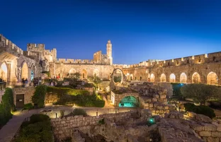
The Cardo Maximus (pictured above) is an excavated a.d. 2nd- to 6th-century street that was Roman and Byzantine Jerusalem’s main market and processional thoroughfare, once bordered by stately columns and lined with portico-shaded shops. The original street is said to have been laid out by the Roman emperor Hadrian (a.d. 117–38) when he rebuilt the city as Aelia Capitolina after the Bar Kochba Revolt of a.d. 132 to 135. In late Byzantine times, the Cardo was extended southward and served as the processional route between the Holy Sepulcher and the Nea, Jerusalem’s two largest churches of that era.
The southern portion of the Cardo is open to the sky; the rest is beneath the modern buildings of the Jewish Quarter. At the end of Or Hayim Street, the Cardo’s imposing columns, found by archaeologists, have been re-erected. As you walk northward along the reconstructed Cardo, where modern tourist shops have been installed, you can see on your right the walled-up facades of Crusader-era shops built into the arches. In this restored section, you can look down well-like structures that reveal how far above the original level of the land the city has risen in its constant rebuilding on the ruins of each wave of destruction. You’ll also see fragments of the city’s defensive walls dating from the First Temple period, around 700 b.c.
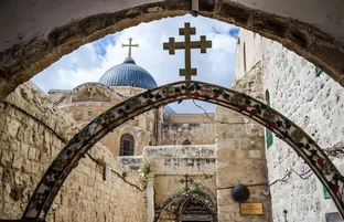
Parallel to the Cardo is the Jewish Quarter Road. Many Jewish Quarter buildings from other times are today recalled by only a single arch, doorway, or minaret. You can inspect the haunting arches, altar, apse, and ruined cloister from the once-lost Crusader Church of Saint Mary of the Teutonic Knights (1128) on Misgav Ladach Street. If you enter the ruins, walk back to the apse, where the windows frame a wonderful view of the Temple Mount. Across from the entrance to the church is a small covered square known as Seven Arches. In the pre-1948 Jewish Quarter, Seven Arches was the heart of a lively market packed with vegetable vendors and customers. To the west, you’ll see the minaret from the Omar Sidna Mosque, and beside it is the rebuilt (2010) Hurva Synagogue, which was once the Great Synagogue of the Jewish Quarter. The name, meaning “ruin,” recalls its difficult and unfortunate history. The original Hurva was built in the 17th century with Ottoman permission but was soon destroyed by Ottoman decree. In the 1850s, a new synagogue was authorized and built. Heavily damaged in the 1948 war, it was demolished after the Jordanians captured the Jewish Quarter. In the decades after 1967, when the Israelis recaptured the Old City, there were a number of movements and plans (including one by visionary American architect Louis Kahn) calling for a new Hurva Synagogue. From 1967 until 2010, the site of the Hurva was marked only by a simple arch, in memory of the Great Synagogue of Jerusalem. The new Hurva, with its landmark dome matching the arch of the original synagogue, is as close as possible to the design of the one that was destroyed in 1948.
Between the minaret and the Hurva is the Ramban Synagogue of Rabbi Moshe Ben-Nachman, who helped reconstitute the Jewish community of Jerusalem in 1267, after it had been obliterated by the Crusaders. You’ll also want to take a look at the complex of Four Sephardic synagogues ★ named for Rabbi Yochanan Ben-Zakkai, whose school, according to tradition, occupied this site during the Second Temple period. One of the four is named for the rabbi himself and another for Eliyahu Ha-Navi (Elijah the Prophet); the other two are the Central Synagogue and the Istanbuli Synagogue. During Muslim rule, no church or synagogue was allowed to exceed the height of the nearest mosque, so to gain headroom, the floors of these synagogues were laid well below ground level. The synagogues are open Sunday to Thursday from 9:30am to 3:45pm and Friday from 9:30am to 1pm.
The Tiferet Israel (or Yisrael) Synagogue (Ashkenazi, or Eastern European Jewish) was founded by Nisan Bek and inaugurated in 1865. Dedicated to the Hasidic Rabbi Israel Friedman of Ruzhin (the synagogue’s name means “Glory of Israel”), it was destroyed after the War of Independence and was restored after 1967.
Moving eastward across the Jewish Quarter in the direction of the Western Wall, you can visit a site showing the neighborhood’s elegant Herodian past.
The Burnt House (tel. 02/626-5906) is a remnant of the destruction of Jerusalem by the Romans in a.d. 70. The wealthy Upper City, site of the present Jewish Quarter, held out for a despairing month after the Lower City and the Temple Mount fell. From these heights, the inhabitants of the Upper City stood on their roofs and watched with horror as the Temple went up in flames. When the Romans finally decided to storm the Upper City, they found little resistance; much of the population was dead or near death from disease and starvation. The Burnt House chillingly brings to light the day when the Romans burned the Upper City. In the 1970s, when archaeologists excavated what had been the kitchen or workroom of this building, they found the forearm bones of a young woman amid the debris. As diggers continued to excavate the area of the room that lay where the arm pointed, they uncovered a wooden spear, almost as if the young woman had been reaching for this weapon when she met her death. Most tantalizing of the household artifacts found on this site is a set of weights marked with the name “Bar Kathros,” a priestly family mentioned in the Talmud (and also in an ancient folk song as one of the wealthy families that oppressed the poor). Historians know the House of Bar Kathros was responsible for the manufacture of incense for the Temple. The excavated house, now preserved beneath modern buildings, offers a brief slideshow about the site. The entrance to the house is marked on a modern door in Seven Arches off Misgav Ladach Road (ask if you have difficulty finding the door). The house is open Sunday to Thursday from 9am to 6pm. Admission is NIS 20.
Al Aqsa Mosque, the third-holiest place of prayer in the world for Muslims (after Mecca and Medina), is the first large edifice you’ll come to. Completed in approximately a.d. 720, it is among the oldest mosques in existence and also among the most beautiful—a vast broad basilica originally nine naves wide (it was rebuilt somewhat smaller after the Crusades). It was in front of the graceful porticos of the Al Aqsa that King Abdullah I of Jordan was assassinated in 1951 by gunmen who believed he was attempting to create a basis for eventual peace in the area. He died here in the presence of his then-15-year-old grandson, the late King Hussein of Jordan.
Note: Although at press time the interiors of Al Aqsa and the Dome of the Rock are closed to visitors, the following information is provided in case they are reopened.
A mosque is a sacred enclosure open to air and light (as opposed to the dark interiors of pagan-era temples). Because a mosque is a sacred precinct, you must remove your shoes before entering. This tradition is very ancient, going back to the time when Moses, approaching the Burning Bush in the Sinai, heard the voice of God telling him to take off his shoes. You must also leave handbags and cameras outside, so you might want to come with a partner who can watch these things for you. Try to stash your wallet and identification papers in a pocket.
After passing through the portico, you will enter a broad, open hall with chandeliers, its floor covered with Oriental rugs. The mosque’s lofty ceilings, supported by a forest of varied columns, are embellished with early Islamic and Byzantine design. Up front, past rows of great marble pillars, is a wood-partitioned platform reserved for the Jordanian royal family. The extraordinary wooden-stair pulpit of the Al Aqsa Mosque, one of Islam’s great artistic treasures for more than 7 centuries, was commissioned by Saladin for the rededication of Al Aqsa as a mosque after the Crusader occupation. Originally built by master artisans from Syria, it was destroyed when a mentally disturbed Australian tourist set fire to Al Aqsa in 1969, and it has been painstakingly reconstructed by craftspeople retrained in techniques that have not been used for hundreds of years. A separate women’s prayer chamber, in blue, is at the right. As you enter Al Aqsa, you face south, in the direction of Mecca. Mihrabs, or prayer niches on the southern wall, remind worshipers of the qibla, or direction they must face during prayers, which are performed five times a day. Unlike most churches and synagogues, mosques contain no pews or chairs. Visitors are invited to view the architecture and design details of the building; however, they are requested not to engage in any prayers.
Leave Al Aqsa, reclaim your shoes and belongings, and turn right. You will only be permitted to walk to the end of the building, but at the far end of the vast pavement is a corner in the city walls. Some say this is the “pinnacle of the Temple” where Satan took Jesus to tempt him (Matt. 4:5). In the distance, you can get a marvelous view of the Mount of Olives and the Kidron Valley.
A stairway leads to the so-called Solomon’s Stables, perhaps first misidentified by the Crusaders. Today, these subterranean chambers are popularly believed to have been the stables for King Solomon’s thousands of horses. The “stables” are actually the substructure supporting this portion of Herod’s vast, artificially created ceremonial platform that is the present surface of the Temple Mount. To add to the confusion about the site, many Muslims believe the “Solomon” referred to is the Ottoman Sultan Suleiman (Solomon) the Magnificent, who rebuilt the walls that surround the present Old City and did extensive repair work on the Dome of the Rock during his reign in the mid-1500s. (For security reasons, this area will most likely be closed to visitors.)
Heading straight across Temple Mount Plaza toward the Dome of the Rock, you’ll pass El-Kas, the fountain where Muslims perform their ritual ablutions before entering the holy places. It is equipped with a circular row of pink marble seats, each of which has a faucet. The fountain is not for use by non-Muslims.
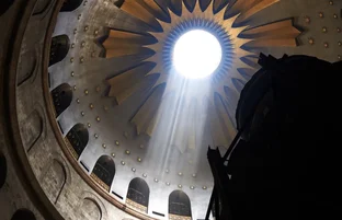
The exterior walls of the dazzling Dome of the Rock are covered with a facade of Persian blue tiles, originally installed by the Ottoman Sultan Suleiman the Magnificent in the mid–16th century. In 1994, under the auspices of Jordan’s King Hussein, the great dome was completely reconstructed and regilded with 80kg (176 lb.) of 24-karat gold. The Dome of the Rock is reached by climbing the broad ceremonial stairs that lead to a decorative archway and a raised center portion of the Temple Mount complex. The Dome of the Rock’s interior is every bit as lavish and intricate as the outside. Plush carpets line the floor, and stained-glass windows line the upper ceiling.
Everything in this beautiful Muslim sanctuary, built in a.d. 691, centers on the rock that occupies the middle of the shrine. According to Islamic tradition, this rock is the spot from which the Prophet Muhammad ascended to view paradise during the Night Journey described in the 17th Sura of the Koran. Tradition holds that when the Prophet rose, the rock tried to follow, and although it failed, the cave beneath the rock was formed. Footprints of Muhammad are pointed out on the rock.
Next to the rock, a few strands of the Prophet Muhammad’s hair are kept in a latticework wooden cabinet. A stairway leads under the rock to a cavelike chamber; according to tradition, this is the Well of the Souls, where it is said the souls of all the dead are gathered. Glass partitions have been erected to stop pilgrims from eroding the sacred rock—for centuries, it was chipped away by the faithful who wanted to bring home a memento.
Jewish tradition holds that on this rock occurred the supreme act of faith that stands at the foundation of the Jewish religion: Abraham’s near-sacrifice of Isaac. Genesis 22 relates how Abraham, in approximately 1800 b.c., followed God’s instructions to go to Moriah and sacrifice Isaac, his beloved son. At the final moment, the voice of God intervened and ordered Abraham to lower his knife. Approximately 900 years later, around 960 b.c., the Temple of Solomon was constructed either on or beside this rock. For the next millennium, the First and Second Temples were located on this site.
From the flat courtyard surrounding the two mosques, you have a wonderful view. To the south are the Valley of Jehoshaphat (Valley of Kidron) and the UN Government House (Mount of Contempt) on the hill. To the east are the lower slopes of the Mount of Olives; the Russian Magdalene Church, with its many onion-shaped golden domes; and the Tomb of the Virgin. Midway up the Mount of Olives is a large, modern, white structure with many levels of arcades that seem built into the side of the slope. This is the vast Mormon Center, constructed in the 1980s and considered to be one of the most beautiful examples of contemporary architecture in Jerusalem. On the crest of the Mount of Olives, above the Church of Mary Magdalene, you’ll see the high-steepled Russian Monastery and the Dome of the Ascension, marking the site from which Jesus is traditionally believed to have ascended to heaven. Farther to the right and a bit downhill is the gray, tear-shaped dome of Dominus Flevit, which commemorates the spot where Jesus wept as he saw a vision of Jerusalem in ruins. Indeed, from the time of the city’s destruction in a.d. 70 until the building of the Dome of the Rock in a.d. 691, Jews traditionally stood near this spot and viewed the actual ruins of the Temple Mount. To the right, on the southern crest of the ridge, is the modern Seven Arches Hotel, built during Jordanian times on the ancient Jewish cemetery of the Mount of Olives.
Take a detour through the Jewish Quarter on your way to the Western Wall and Temple Mount. By doing so, you’ll save an uphill walk, as the wall lies well below most of the quarter.
The Jewish Quarter lies directly west of the Temple Mount and sits on a higher hill than the Temple Mount itself. With the exception of the sacred Temple Mount, the entire original city of Jerusalem from the time of David (1000 b.c.) was outside the walls of the present Old City, just downhill and to the south. Over the centuries, ancient Jerusalem spread northward, up the slope. By the time of King Hezekiah, around 700 b.c., much of the uphill area now occupied by the Jewish Quarter had become a new addition to the city, surrounded by the Broad Wall. But the wall and its many towers were not strong enough to keep out Nebuchadnezzar of Babylon, who conquered and laid waste to Jerusalem in 586 b.c.
Jews returned to rebuild Jerusalem after the Babylonian Captivity, but it took centuries for the city to regain its former size. In the late Second Temple period, Jerusalem again expanded uphill, and the area that is now the Jewish Quarter was inhabited once more and developed into an aristocratic and priestly residential neighborhood. The main market street of Herodian Jerusalem developed at the bottom of the Tyropoeon (Cheesemakers’) Valley, which separates the heights of the present Jewish Quarter from the Temple Mount. The market street continued northward to the Damascus Gate. For thousands of religious pilgrims to make their way to the Temple Mount without becoming entangled in the crush of the market, two massive pedestrian staircases and overpasses were constructed above the market street. By the a.d. 1st century, Jerusalem had expanded northward, beyond the present Old City’s northern wall. A new, bustling Upper Market developed where the present Suq Khan es-Zeit market leads toward the Damascus Gate. The original City of David, the oldest part of town, came to be known as the Lower City.
Jerusalem was again leveled in a.d. 70 by Roman armies (the remains of houses burned in that conflagration have been uncovered in what is now the Jewish Quarter); 65 years after the Romans destroyed Jerusalem, they (and later their Byzantine successors) rebuilt the city. You can visit several recently uncovered vestiges of Roman/Byzantine times in the Jewish Quarter, including the ruins of the gigantic Nea Church and the southern end of the city’s colonnaded north-south thoroughfare, the Cardo Maximus. Jews were forbidden to reside in Jerusalem during the long Byzantine period, which began in a.d. 326, and many Jewish inhabitants of the area allied themselves with the then-pagan Persians, who conquered and occupied Jerusalem from a.d. 614 to 629. The Byzantines returned in a.d. 629, followed quickly by the Muslims, who conquered Jerusalem in a.d. 638. Under their more tolerant rule, a permanent Jewish community was reestablished in the northeast quadrant of the Old City, on the site of the present Muslim Quarter. The Crusaders conquered Jerusalem in 1099 and celebrated their triumph by massacring most of the city’s Jewish population as well as thousands of Muslims and local Christians.
In 1267, after the Crusaders were driven from Jerusalem, a small Jewish community reestablished itself in the ruins of what is now the Jewish Quarter. This area has been the center of the Jewish community in the Old City ever since.
The Jewish Quarter’s most recent destruction came during and after the 1948 war with Jordan, when all the synagogues and most other buildings in the quarter were severely damaged and over the next 2 decades fell into almost total ruin; many were systematically demolished. Since the Israeli conquest of the Old City during the 1967 war, the quarter has been rebuilt and revitalized. Although some original buildings have been carefully re-created, and many new structures were designed to blend in with them, the basic nature of the current Jewish Quarter is quite different from the impoverished, densely populated neighborhoods that existed here before 1948.
Following St. James Road (a left turn off Armenian Patriarchate Rd.) to where it becomes Or Hayim Street, you’ll come to the Old Yishuv Court Museum, 6 Or Hayim St. (tel. 02/628-4636). This small museum displays artifacts and crafts typical of Ashkenazi and Sephardic communities in the Jewish Quarter from the middle of the 19th century to the end of Turkish rule in 1917. Admission is NIS 20, and it’s open Sunday to Thursday from 10am to 3pm, Fri 10am–1pm.
The Cardo Maximus (pictured above) is an excavated a.d. 2nd- to 6th-century street that was Roman and Byzantine Jerusalem’s main market and processional thoroughfare, once bordered by stately columns and lined with portico-shaded shops. The original street is said to have been laid out by the Roman emperor Hadrian (a.d. 117–38) when he rebuilt the city as Aelia Capitolina after the Bar Kochba Revolt of a.d. 132 to 135. In late Byzantine times, the Cardo was extended southward and served as the processional route between the Holy Sepulcher and the Nea, Jerusalem’s two largest churches of that era.
The southern portion of the Cardo is open to the sky; the rest is beneath the modern buildings of the Jewish Quarter. At the end of Or Hayim Street, the Cardo’s imposing columns, found by archaeologists, have been re-erected. As you walk northward along the reconstructed Cardo, where modern tourist shops have been installed, you can see on your right the walled-up facades of Crusader-era shops built into the arches. In this restored section, you can look down well-like structures that reveal how far above the original level of the land the city has risen in its constant rebuilding on the ruins of each wave of destruction. You’ll also see fragments of the city’s defensive walls dating from the First Temple period, around 700 b.c.
Parallel to the Cardo is the Jewish Quarter Road. Many Jewish Quarter buildings from other times are today recalled by only a single arch, doorway, or minaret. You can inspect the haunting arches, altar, apse, and ruined cloister from the once-lost Crusader Church of Saint Mary of the Teutonic Knights (1128) on Misgav Ladach Street. If you enter the ruins, walk back to the apse, where the windows frame a wonderful view of the Temple Mount. Across from the entrance to the church is a small covered square known as Seven Arches. In the pre-1948 Jewish Quarter, Seven Arches was the heart of a lively market packed with vegetable vendors and customers. To the west, you’ll see the minaret from the Omar Sidna Mosque, and beside it is the rebuilt (2010) Hurva Synagogue, which was once the Great Synagogue of the Jewish Quarter. The name, meaning “ruin,” recalls its difficult and unfortunate history. The original Hurva was built in the 17th century with Ottoman permission but was soon destroyed by Ottoman decree. In the 1850s, a new synagogue was authorized and built. Heavily damaged in the 1948 war, it was demolished after the Jordanians captured the Jewish Quarter. In the decades after 1967, when the Israelis recaptured the Old City, there were a number of movements and plans (including one by visionary American architect Louis Kahn) calling for a new Hurva Synagogue. From 1967 until 2010, the site of the Hurva was marked only by a simple arch, in memory of the Great Synagogue of Jerusalem. The new Hurva, with its landmark dome matching the arch of the original synagogue, is as close as possible to the design of the one that was destroyed in 1948.
Between the minaret and the Hurva is the Ramban Synagogue of Rabbi Moshe Ben-Nachman, who helped reconstitute the Jewish community of Jerusalem in 1267, after it had been obliterated by the Crusaders. You’ll also want to take a look at the complex of Four Sephardic synagogues ★ named for Rabbi Yochanan Ben-Zakkai, whose school, according to tradition, occupied this site during the Second Temple period. One of the four is named for the rabbi himself and another for Eliyahu Ha-Navi (Elijah the Prophet); the other two are the Central Synagogue and the Istanbuli Synagogue. During Muslim rule, no church or synagogue was allowed to exceed the height of the nearest mosque, so to gain headroom, the floors of these synagogues were laid well below ground level. The synagogues are open Sunday to Thursday from 9:30am to 3:45pm and Friday from 9:30am to 1pm.
The Tiferet Israel (or Yisrael) Synagogue (Ashkenazi, or Eastern European Jewish) was founded by Nisan Bek and inaugurated in 1865. Dedicated to the Hasidic Rabbi Israel Friedman of Ruzhin (the synagogue’s name means “Glory of Israel”), it was destroyed after the War of Independence and was restored after 1967.
Moving eastward across the Jewish Quarter in the direction of the Western Wall, you can visit a site showing the neighborhood’s elegant Herodian past.
The Burnt House (tel. 02/626-5906) is a remnant of the destruction of Jerusalem by the Romans in a.d. 70. The wealthy Upper City, site of the present Jewish Quarter, held out for a despairing month after the Lower City and the Temple Mount fell. From these heights, the inhabitants of the Upper City stood on their roofs and watched with horror as the Temple went up in flames. When the Romans finally decided to storm the Upper City, they found little resistance; much of the population was dead or near death from disease and starvation. The Burnt House chillingly brings to light the day when the Romans burned the Upper City. In the 1970s, when archaeologists excavated what had been the kitchen or workroom of this building, they found the forearm bones of a young woman amid the debris. As diggers continued to excavate the area of the room that lay where the arm pointed, they uncovered a wooden spear, almost as if the young woman had been reaching for this weapon when she met her death. Most tantalizing of the household artifacts found on this site is a set of weights marked with the name “Bar Kathros,” a priestly family mentioned in the Talmud (and also in an ancient folk song as one of the wealthy families that oppressed the poor). Historians know the House of Bar Kathros was responsible for the manufacture of incense for the Temple. The excavated house, now preserved beneath modern buildings, offers a brief slideshow about the site. The entrance to the house is marked on a modern door in Seven Arches off Misgav Ladach Road (ask if you have difficulty finding the door). The house is open Sunday to Thursday from 9am to 6pm. Admission is NIS 20.
Al Aqsa Mosque, the third-holiest place of prayer in the world for Muslims (after Mecca and Medina), is the first large edifice you’ll come to. Completed in approximately a.d. 720, it is among the oldest mosques in existence and also among the most beautiful—a vast broad basilica originally nine naves wide (it was rebuilt somewhat smaller after the Crusades). It was in front of the graceful porticos of the Al Aqsa that King Abdullah I of Jordan was assassinated in 1951 by gunmen who believed he was attempting to create a basis for eventual peace in the area. He died here in the presence of his then-15-year-old grandson, the late King Hussein of Jordan.
Note: Although at press time the interiors of Al Aqsa and the Dome of the Rock are closed to visitors, the following information is provided in case they are reopened.
A mosque is a sacred enclosure open to air and light (as opposed to the dark interiors of pagan-era temples). Because a mosque is a sacred precinct, you must remove your shoes before entering. This tradition is very ancient, going back to the time when Moses, approaching the Burning Bush in the Sinai, heard the voice of God telling him to take off his shoes. You must also leave handbags and cameras outside, so you might want to come with a partner who can watch these things for you. Try to stash your wallet and identification papers in a pocket.
After passing through the portico, you will enter a broad, open hall with chandeliers, its floor covered with Oriental rugs. The mosque’s lofty ceilings, supported by a forest of varied columns, are embellished with early Islamic and Byzantine design. Up front, past rows of great marble pillars, is a wood-partitioned platform reserved for the Jordanian royal family. The extraordinary wooden-stair pulpit of the Al Aqsa Mosque, one of Islam’s great artistic treasures for more than 7 centuries, was commissioned by Saladin for the rededication of Al Aqsa as a mosque after the Crusader occupation. Originally built by master artisans from Syria, it was destroyed when a mentally disturbed Australian tourist set fire to Al Aqsa in 1969, and it has been painstakingly reconstructed by craftspeople retrained in techniques that have not been used for hundreds of years. A separate women’s prayer chamber, in blue, is at the right. As you enter Al Aqsa, you face south, in the direction of Mecca. Mihrabs, or prayer niches on the southern wall, remind worshipers of the qibla, or direction they must face during prayers, which are performed five times a day. Unlike most churches and synagogues, mosques contain no pews or chairs. Visitors are invited to view the architecture and design details of the building; however, they are requested not to engage in any prayers.
Leave Al Aqsa, reclaim your shoes and belongings, and turn right. You will only be permitted to walk to the end of the building, but at the far end of the vast pavement is a corner in the city walls. Some say this is the “pinnacle of the Temple” where Satan took Jesus to tempt him (Matt. 4:5). In the distance, you can get a marvelous view of the Mount of Olives and the Kidron Valley.
A stairway leads to the so-called Solomon’s Stables, perhaps first misidentified by the Crusaders. Today, these subterranean chambers are popularly believed to have been the stables for King Solomon’s thousands of horses. The “stables” are actually the substructure supporting this portion of Herod’s vast, artificially created ceremonial platform that is the present surface of the Temple Mount. To add to the confusion about the site, many Muslims believe the “Solomon” referred to is the Ottoman Sultan Suleiman (Solomon) the Magnificent, who rebuilt the walls that surround the present Old City and did extensive repair work on the Dome of the Rock during his reign in the mid-1500s. (For security reasons, this area will most likely be closed to visitors.)
Heading straight across Temple Mount Plaza toward the Dome of the Rock, you’ll pass El-Kas, the fountain where Muslims perform their ritual ablutions before entering the holy places. It is equipped with a circular row of pink marble seats, each of which has a faucet. The fountain is not for use by non-Muslims.
The exterior walls of the dazzling Dome of the Rock are covered with a facade of Persian blue tiles, originally installed by the Ottoman Sultan Suleiman the Magnificent in the mid–16th century. In 1994, under the auspices of Jordan’s King Hussein, the great dome was completely reconstructed and regilded with 80kg (176 lb.) of 24-karat gold. The Dome of the Rock is reached by climbing the broad ceremonial stairs that lead to a decorative archway and a raised center portion of the Temple Mount complex. The Dome of the Rock’s interior is every bit as lavish and intricate as the outside. Plush carpets line the floor, and stained-glass windows line the upper ceiling.
Everything in this beautiful Muslim sanctuary, built in a.d. 691, centers on the rock that occupies the middle of the shrine. According to Islamic tradition, this rock is the spot from which the Prophet Muhammad ascended to view paradise during the Night Journey described in the 17th Sura of the Koran. Tradition holds that when the Prophet rose, the rock tried to follow, and although it failed, the cave beneath the rock was formed. Footprints of Muhammad are pointed out on the rock.
Next to the rock, a few strands of the Prophet Muhammad’s hair are kept in a latticework wooden cabinet. A stairway leads under the rock to a cavelike chamber; according to tradition, this is the Well of the Souls, where it is said the souls of all the dead are gathered. Glass partitions have been erected to stop pilgrims from eroding the sacred rock—for centuries, it was chipped away by the faithful who wanted to bring home a memento.
Jewish tradition holds that on this rock occurred the supreme act of faith that stands at the foundation of the Jewish religion: Abraham’s near-sacrifice of Isaac. Genesis 22 relates how Abraham, in approximately 1800 b.c., followed God’s instructions to go to Moriah and sacrifice Isaac, his beloved son. At the final moment, the voice of God intervened and ordered Abraham to lower his knife. Approximately 900 years later, around 960 b.c., the Temple of Solomon was constructed either on or beside this rock. For the next millennium, the First and Second Temples were located on this site.
From the flat courtyard surrounding the two mosques, you have a wonderful view. To the south are the Valley of Jehoshaphat (Valley of Kidron) and the UN Government House (Mount of Contempt) on the hill. To the east are the lower slopes of the Mount of Olives; the Russian Magdalene Church, with its many onion-shaped golden domes; and the Tomb of the Virgin. Midway up the Mount of Olives is a large, modern, white structure with many levels of arcades that seem built into the side of the slope. This is the vast Mormon Center, constructed in the 1980s and considered to be one of the most beautiful examples of contemporary architecture in Jerusalem. On the crest of the Mount of Olives, above the Church of Mary Magdalene, you’ll see the high-steepled Russian Monastery and the Dome of the Ascension, marking the site from which Jesus is traditionally believed to have ascended to heaven. Farther to the right and a bit downhill is the gray, tear-shaped dome of Dominus Flevit, which commemorates the spot where Jesus wept as he saw a vision of Jerusalem in ruins. Indeed, from the time of the city’s destruction in a.d. 70 until the building of the Dome of the Rock in a.d. 691, Jews traditionally stood near this spot and viewed the actual ruins of the Temple Mount. To the right, on the southern crest of the ridge, is the modern Seven Arches Hotel, built during Jordanian times on the ancient Jewish cemetery of the Mount of Olives.
Details
Bookstore
Available as paperback
and as e-book.